基本情報
SCANnavi™撮影・Scan to BIM受託・インフラデジタルツイン化まで
一貫対応。測量業務を従来比1/5に短縮。実機体験受付中。
SCANnavi™ 3D survey, Scan to BIM modeling, and digital twin
development — proven at Osaka’s Ajigawa Water Gate and Kyoto
historic buildings. Survey time reduced by 80%.
Live demos at our booth.
出展製品・サービス
SCANnavi™(スキャンナビ)
SCANnavi™ – 3D Point Cloud Survey & Drawing Creation Service
SCANnaviは、地盤ネット株式会社が提供する3D点群データを活用した
現況測量・図面作成支援ソリューションです。
3Dスキャンカメラ「4DKanKan® Meta」を使用し、現場を歩くだけで
高精度な点群データとパノラマ映像を同時取得。
専門的な測量知識や特別なスキルは一切不要です。
■ 解決できる課題
・測量技術者の不足・育成コストの高さ
・平面図依存による手戻りと情報断絶
・現地再調査による移動コスト・工期の長期化
■ サービスの特長
・測量業務時間を従来比約1/5に短縮(作業時間80%削減)
・取得データはURLひとつで即時共有。遠隔地からも現場確認が可能
・BIMとのデータ連携に対応。設計・施工・管理の全工程で活用可能
・クラウドが処理を自動化。専用ソフト不要でチームとリアルタイム共有
■ 主な活用シーン
改修工事の現況把握/進捗管理・記録/設備点検の立体記録/
BIM導入時の3Dデータ取得/図面が残っていない既存建物の図面化
展示ブースでは実機デモを実施。実データの操作もその場で体験できます。
SCANnavi™ is a 3D point cloud-based survey and drawing
creation support solution provided by Jibannet Co., Ltd.
Using the 3D scanning camera "4DKanKan® Meta" developed by
GeoSign Co., Ltd., users can simultaneously capture
high-precision point cloud data (accuracy within a few
millimeters) and panoramic imagery simply by walking through
a site. No specialist surveying knowledge or technical skills
are required.
【Key Challenges Solved】
- Shortage of skilled surveyors and high training costs
- Rework and information gaps caused by reliance on 2D plans
- High cost and time loss from repeated site visits
【Service Features】
- Reduces survey work time to approximately 1/5 of conventional
methods (80% reduction in work hours)
- Data is instantly shareable via a single URL, enabling remote
site confirmation from anywhere
- Full BIM data integration for use across design, construction,
and facility management workflows
- Cloud-based automatic processing — no dedicated software needed,
enabling real-time team collaboration
【Primary Use Cases】
As-built surveys for renovation projects / Construction progress
monitoring and documentation / Equipment inspection with 3D spatial
records / 3D data acquisition for BIM implementation / Drawing
creation for existing buildings with no remaining plans
Live equipment demos and hands-on data operation are available
at our exhibition booth.

Scan to BIMソリューション
Scan to BIM Solution – Point Cloud to BIM Modeling & Drawing Creation
Scan to BIMソリューションは、3Dスキャンカメラ「4DKanKan® Meta」で
取得した点群データをもとに、BIMモデルの構築と建物図面の作成までを
一貫して支援するサービスです。
従来、図面のない既存建物のBIM化には、専門技術者による長期の現地計測
と膨大な手作業が必要でした。本サービスでは、現場での点群取得から
BIMモデリング・図面化まで地盤ネットが受託対応することで、
設計事務所・建設会社のBIM推進を強力にサポートします。
■ サービスフロー
(1) 4DKanKan® MetaによるSCANnavi撮影(現場)
(2) 点群データの自動クラウド処理
(3) 点群をもとにしたBIMモデリング(受託)
(4) 平面図・立面図・断面図などの図面作成・納品
■ こんな課題を解決
・既存建物の図面が残っておらず、改修設計に時間がかかっている
・BIM化したいが社内にモデリングリソースがない
・測量から図面化まで一括で外注したい
建物の規模・用途を問わず対応可能。まずはブースにてご相談ください。
The Scan to BIM Solution is a comprehensive service provided
by Jibannet Co., Ltd. that takes point cloud data captured
by the 3D scanning camera "4DKanKan® Meta" and delivers
complete BIM modeling and architectural drawing creation.
Traditionally, converting existing buildings without drawings
into BIM models required lengthy on-site measurement by
specialist engineers and extensive manual work. With this
service, Jibannet handles the entire workflow — from
on-site point cloud capture through to BIM modeling and
drawing output — as a fully outsourced solution, enabling
design firms and construction companies to accelerate their
BIM adoption.
【Service Workflow】
(1) On-site scanning with SCANnavi™ using 4DKanKan® Meta
(2) Automatic point cloud processing via cloud
(3) BIM modeling based on point cloud data (outsourced)
(4) Delivery of floor plans, elevations, sections, and
other drawings
【Challenges This Service Solves】
- No existing drawings for a building, making renovation
design time-consuming
- No in-house BIM modeling capacity despite a desire to
adopt BIM
- Need for a single vendor to handle everything from
survey to drawing delivery
Applicable to buildings of any scale or use type.
Please visit our booth for a consultation.
デジタルツイン活用ソリューション
Digital Twin Solution – Infrastructure & Building Digitization
デジタルツイン活用ソリューションは、4DKanKan® Metaによる高精度な
3Dスキャンデータを活用し、建物・インフラ・公共施設をデジタル空間上に
リアルに再現するサービスです。
一度スキャンすれば、点群データとパノラマ映像をURLひとつで共有・閲覧
できるデジタルツインとして活用可能。現地に行かずとも維持管理・点検・
設計検討ができる環境を実現します。
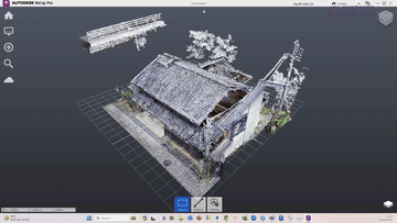
■ 実績事例
【大阪市 安治川水門】
大型水門構造物を高精度点群データで記録。維持管理・補修計画の
効率化に向けたインフラデジタルツイン化を実現。
【京都市 既存建物(町屋など)】
図面が存在しない歴史的建造物を点群データで精密に記録し、
BIM連携による図面化・保存・修復計画への活用を実現。
■ こんな用途に対応
・老朽インフラの維持管理・定期点検の記録・効率化
・文化財・歴史的建造物のデジタルアーカイブ
・改修工事前の現況把握と設計精度の向上
・遠隔地からの現場確認・進捗共有
点群データは竣工後も資産として蓄積・活用可能。
「撮って終わり」ではなく、長期的な現場DXの基盤を構築します。
The Digital Twin Solution uses high-precision 3D scan data
captured by the 4DKanKan® Meta to create accurate digital
replicas of buildings, infrastructure, and public facilities
in a virtual environment.
Once a site is scanned, the point cloud data and panoramic
imagery are immediately available as a shareable digital
twin via a single URL — enabling maintenance management,
inspections, and design reviews without the need for
on-site visits.
【Proven Case Studies】
[Ajigawa Water Gate – Osaka City]
A large water gate structure was digitally recorded with
high-precision point cloud data. The resulting infrastructure
digital twin enables more efficient maintenance management
and repair planning.
[Existing Buildings (Traditional Townhouses) – Kyoto City]
Historic buildings with no remaining drawings were precisely
captured in point cloud format. The data supports BIM
integration, drawing creation, preservation documentation,
and restoration planning.
【Applicable Use Cases】
- Maintenance and periodic inspection records for aging
infrastructure
- Digital archiving of cultural heritage and historic buildings
- Pre-renovation as-built surveys for improved design accuracy
- Remote site confirmation and construction progress sharing
Point cloud data continues to serve as a long-term asset
after project completion — building a sustainable foundation
for ongoing construction DX rather than a one-time scan.
共同出展社:ジオサイン
共同出展社:GeoSign
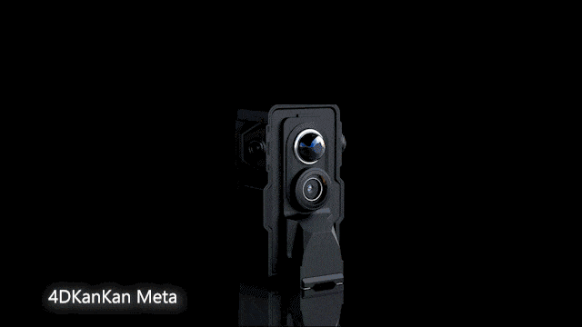
4DKanKan® Meta
4DKanKan® Meta
4DKanKan® Metaは1台2役で16Kパノラマ写真と±1cmの点群を同時撮影することができ、クラウド上で簡単にデジタル空間データを閲覧・共有が可能なデジタルツインカメラです。
4DKanKan® Meta is a digital twin camera that serves two functions in one device: it can simultaneously capture 16K panoramic photos and point cloud data with an accuracy of ±1 cm, while also enabling easy viewing and sharing of digital spatial data in the cloud.