基本情報
出展製品・サービス
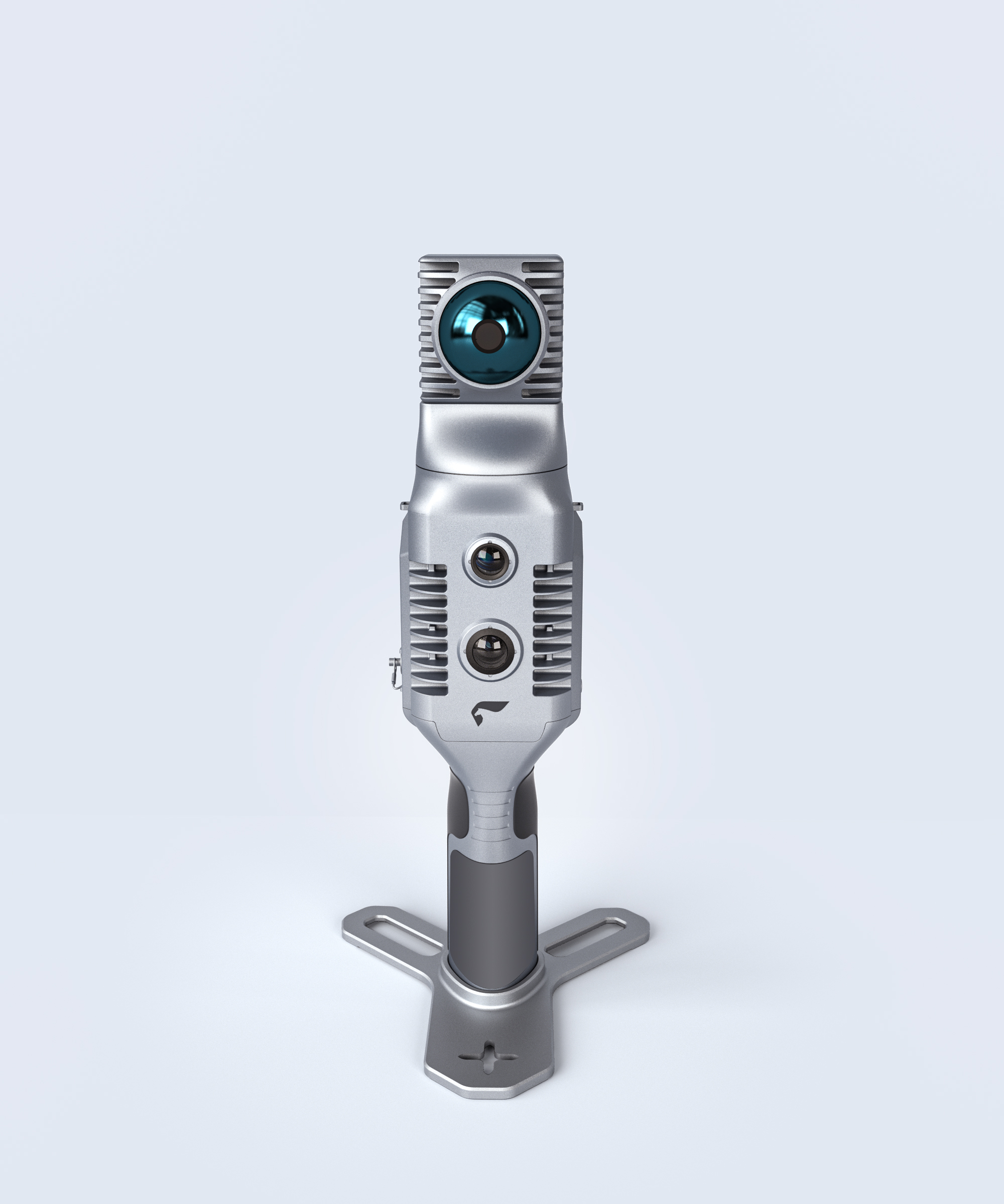
SLAM200 SLAMレーザースキャナ
SLAM200 SLAM laser scanner
SLAM200:空中・地上統合型モバイルマッピングシステム
超軽量・マルチシーン対応
✓ 本体重量1.4kg — 業界トップクラスの携帯性
✓ 空中・地上の両方に対応:ドローン(DJI M300/350など)、ハンドヘルド、車載、バックパック、三脚での運用が可能
✓ 屋内・屋外をシームレスに:GPS非環境下(工場・トンネル・建物内)でも高度なSLAM技術により安定動作
高性能センサーフュージョン
✓ 32ラインLiDAR:測定距離300m/スキャンレート640,000点/秒
✓ デュアル12MP魚眼カメラ:リアルタイムパノラマ映像+自動カラーポイントクラウド
✓ GNSS/RTK内蔵:屋外でのセンチメートル級絶対位置測位
精密性
✓ <1cmの精度(RTK/標定点使用時)— 測量級の結果を実現
リアルタイム処理
✓ 同時マッピング・カラーリング・位置推定をライブで実行
✓ 後処理ほぼゼロ、プロジェクト時間を50%以上削減
360°フルカバレッジ
✓ 飛行高度120m(ドローン時)/全方向スキャン
SLAM200: Air-Ground Integrated Mobile Mapping for Indoor/Outdoor Precision
Ultra-Light & Multi-Scene Ready
✓ 1.4kg host unit — industry-leading portability.
✓ Air-ground versatility: Compatible with drones (e.g., DJI M300/350), handheld, vehicle, backpack, and tripod modes.
✓ Indoor/outdoor agility: Operates flawlessly in GPS-denied environments (factories, tunnels, buildings) using advanced SLAM tech.
High-Performance Sensor Fusion
✓ 32-line LiDAR: 300m range | 640,000 pts/sec scan rate.
✓ Dual 12MP fisheye cameras: Real-time panoramic imaging + auto-colorized point clouds.
✓ Built-in GNSS/RTK: Centimeter-level absolute positioning (outdoor).
Precision Redefined
✓ <1cm accuracy (with RTK/control points) for survey-grade results.
Real-Time Intelligence
✓ Live processing: Simultaneous mapping, coloring, and positioning.
✓ Cut project time by 50%+ with near-zero post-processing.
360° Full Coverage
✓ 120m flight altitude (drone mode) | Omnidirectional scanning.
SLAM200E SLAMレーザースキャナ
SLAM200E SLAM laser scanner
SLAM200Eでマッピングをシンプルに ????
道路・点群・3Dモデルに対応した高精度ハンドヘルドLiDAR
✓ リアルタイム3Dマッピング
✓ デュアル12MPパノラマカメラ ????
✓ 相対精度5mm、RTK対応
✓ 道路のベクトル化とモデリングが簡単に
Scan. Map. Visualize. Repeat.
Mapping made simple with SLAM200E ????
High-precision handheld LiDAR for roads, points, and 3D models.
Real-time 3D mapping
Dual 12MP panoramic cameras ????
5 mm relative accuracy, RTK-ready
Road vectorization & modeling made easy
Scan. Map. Visualize. Repeat.
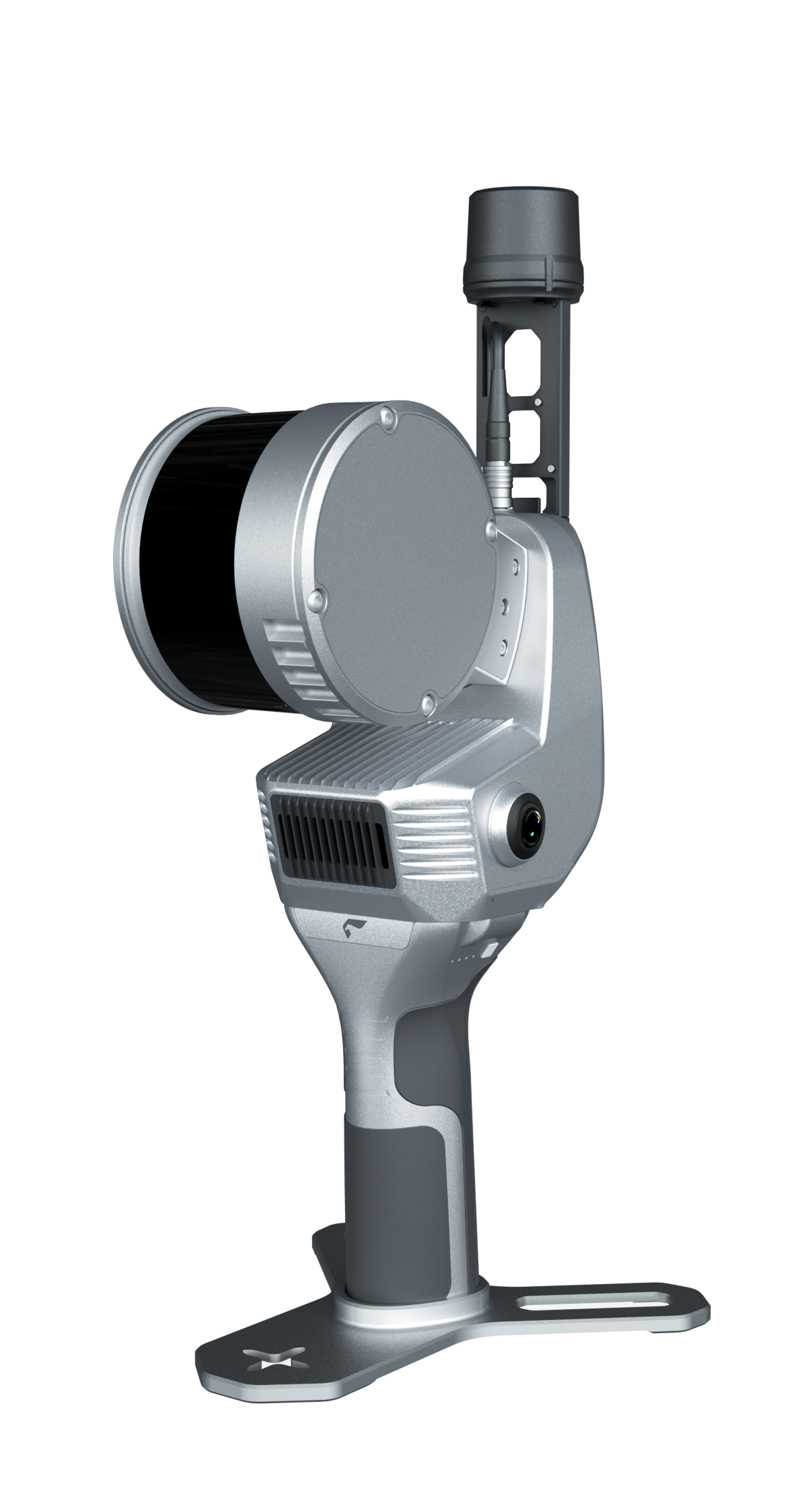
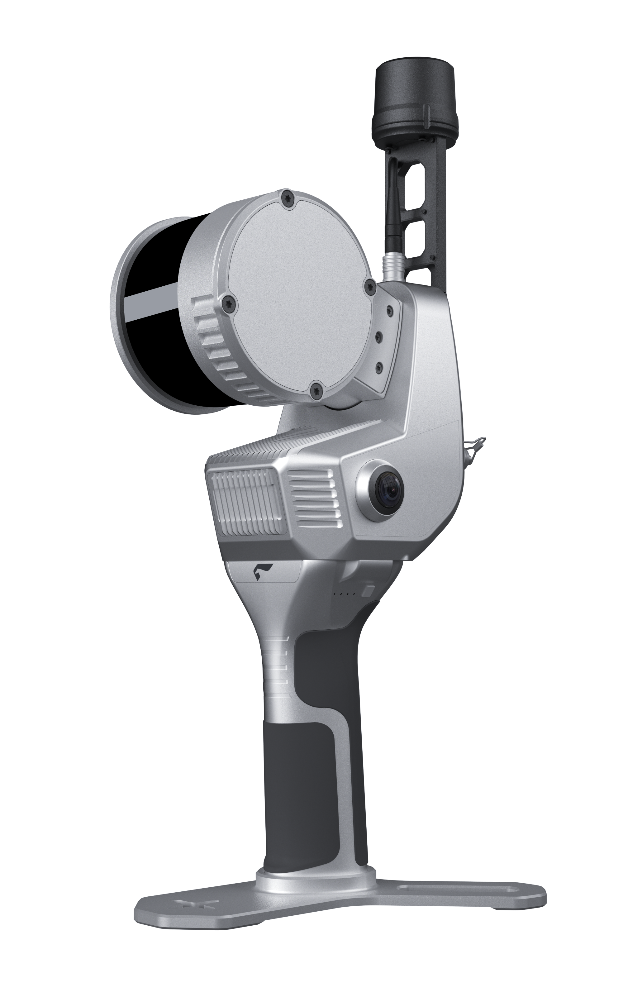
SLAM2000 SLAMレーザースキャナ
SLAM2000 SLAM laser scanner
Feima Robotics、SLAM2000を発表 — 過酷な環境向けの高精度・携帯型3Dレーザースキャナ。狭い屋内空間のマッピング、緊急対応、複雑な産業施設の測量まで、リアルタイムで卓越した精度を実現します。
✅ 主な特徴
パノラマ360°レーザー視野角 — 完全なカバレッジ
リアルタイムマッピング&データ出力
12MPテクスチャ&ビジュアルカメラを内蔵
高精度慣性航法&キャリブレーション
RTK、バックパック、三脚などに対応し拡張可能
堅牢設計:IP54、-20℃~50℃での動作
✅ 性能ハイライト
点群厚:≤1cm(後処理時)
相対精度:≤2cm(後処理時)
測定距離:最大70m
軽量設計:本体重量925g、バッテリー駆動時間95分
✅ 推奨用途
屋内/地下マッピング
トンネル・洞窟の測量
緊急救助活動
体積算定・BIMアプリケーション
スマートファクトリー&デジタルツイン
Feima Robotics is proud to unveil the SLAM2000 — a high-precision, portable 3D laser scanner built for the most demanding environments. Whether you’re mapping tight indoor spaces, conducting emergency response, or surveying complex industrial sites, SLAM2000 delivers real-time results with exceptional accuracy.
✅ Key Features:
Panoramic 360° laser FOV for full coverage
Real-time mapping & data output
Integrated 12MP texture & visual cameras
High-accuracy inertial navigation & calibration
Expandable with RTK, backpack, tripod, and more
Rugged design: IP54, -20°C to 50°C operation
✅ Performance Highlights:
Point cloud thickness: ≤1cm (post-processing)
Relative accuracy: ≤2cm (post-processing)
Works up to 70m range
Lightweight: 925g (host), 95 mins battery life
✅ Ideal For:
Indoor/underground mapping
Tunnel & cave surveying
Emergency rescue operations
Volumetric & BIM applications
Smart factories & digital twins