基本情報
出展製品・サービス
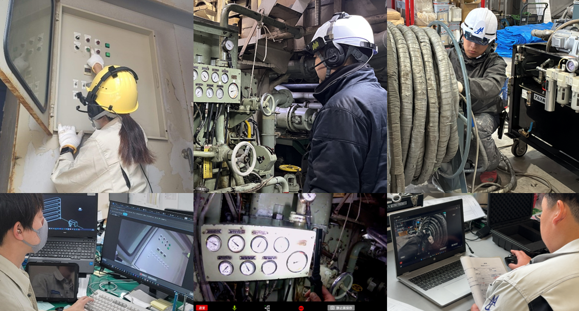
遠隔作業支援システム「リモサポ」
Remote Work Support System “Remosapo”
遠隔作業支援システム「リモサポ」は、ウェアラブルカメラを装着した作業者の視界映像をリアルタイムで共有し、離れた場所から作業の確認・指示・支援を行えるシステムです。
現場に赴くことなく複数現場の状況を同時に把握できるため、移動時間や出張コストの削減と迅速な意思決定を実現します。
建設業では、遠隔臨場をはじめ、施工状況の確認、工程管理、進捗共有、安全確認、完了検査など幅広い場面で活用されており、現場と発注者・管理者をリアルタイムにつなぎます。
これにより、現地立会の負担軽減や確認業務の効率化、コミュニケーションの円滑化に貢献します。
また、高所・狭所など複数人での作業が難しい危険を伴う現場においても、遠隔から作業状況や安全面の確認が可能となり、効率化に加えて安全管理の強化にもつながります。
さらに、リモサポは業務改善と教育を同時に進め、若手の早期戦力化にも貢献します。若手の心理的不安を軽減しながら、現場に即した実践的な教育が可能です。
加えて、一人称視点の映像は「ギノサポらくらくマニュアル」と組み合わせることで、実践的な動画マニュアルとして教育や技能継承にも活用できます。
リモサポは、現場と遠隔地をつなぐだけでなく、判断・指示・記録を一体化し、建設現場のDX推進を支援します。
“Remosapo” is a remote work support system that shares a worker’s first-person view in real time through a wearable camera, enabling remote monitoring, instruction, and support from any location.
By allowing multiple sites to be monitored simultaneously without the need for on-site visits, it reduces travel time and costs while enabling faster decision-making.
In the construction industry, it is used for a wide range of applications including remote witnessing, construction progress checks, process management, progress sharing, safety confirmation, and final inspections, connecting field workers with project owners and managers in real time.
This helps reduce the burden of on-site attendance, improve operational efficiency, and streamline communication.
It also supports safer operations in hazardous environments such as elevated or confined spaces, where working with multiple people can be difficult.
By enabling remote confirmation of work conditions and safety status, it improves both efficiency and safety management.
In addition, Remosapo supports both operational improvement and workforce training, helping younger workers become productive more quickly. It reduces psychological stress for less experienced workers while enabling practical, on-site training.
Furthermore, first-person video footage can be combined with “Ginosapo Easy Manual” to create practical video manuals for training and skill transfer.
Remosapo integrates monitoring, instruction, and documentation to support digital transformation in construction.
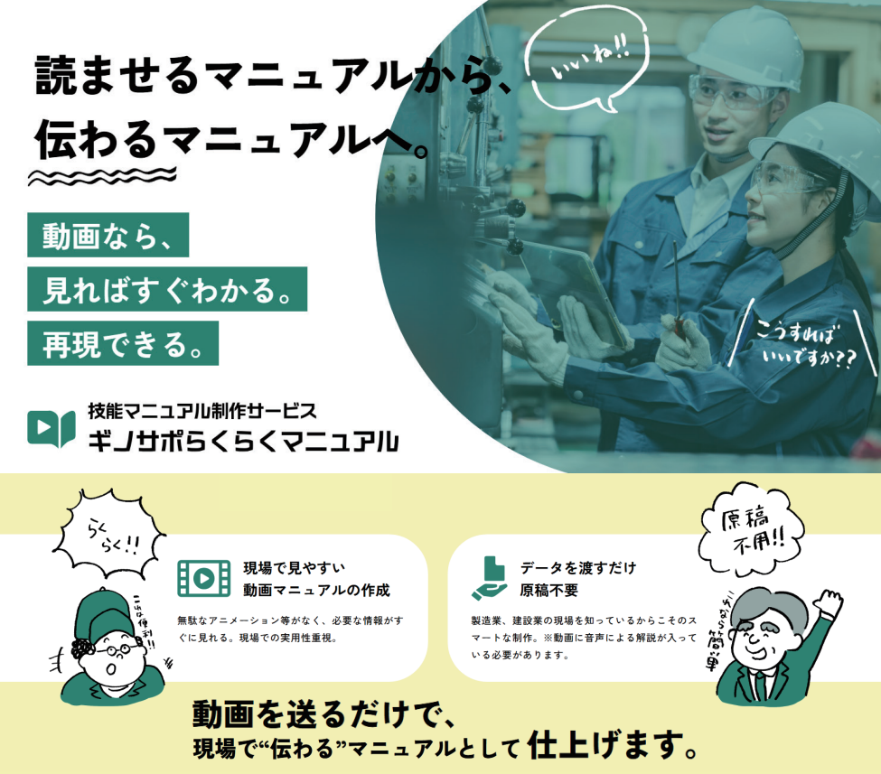
技能マニュアル制作サービス「ギノサポらくらくマニュアル」
Skill Manual Creation Service “Ginosapo Easy Manual”
「ギノサポらくらくマニュアル」は、現場で撮影した作業動画を送るだけで、弊社の編集チームが“伝わる”動画マニュアルを作成する技能マニュアル制作サービスです。
AI自動生成ではなく、人が作業内容を確認し、手順や注意点をテロップや図解で整理し、5分程度で理解しやすい実践的な教育コンテンツに仕上げます。
お客様自身で編集ソフトを扱う必要はなく、撮影後の編集作業はすべて弊社で行うため、本来の業務に集中しながら、効率よく動画マニュアルを整備していただけます。
作業手順や安全確認、重機操作、点検業務など、言葉だけでは伝わりにくい技能や判断も、現場の実作業を可視化することで、ベテラン作業者の動きや判断のポイントを分かりやすく共有できます。
さらに、リモサポやアイトラッキングで撮影した一人称視点映像を活用することで、実務に即した再現性の高い教育が可能です。
新人教育やOJTでは、予習・復習にも活用でき、教育負担の軽減と理解度向上に貢献します。
また、おまかせ編集で作成した初稿動画は、「追加したい情報」「不要な表現」などを簡単にフィードバックできるため、ご要望に沿った内容へ調整可能です。
お客様の意図を反映しながら、伝わりやすく実用的な動画へ仕上げます。
完成動画はmp4形式で納品するため、利用期限なく社内資産として継続的に活用できます。
ギノサポらくらくマニュアルは、技能伝承の効率化と教育品質の標準化を実現し、建設現場の人材育成とDX推進を支援します。
“Ginosapo Easy Manual” is a skill manual creation service in which our editing team turns on-site work videos into clear and practical training manuals.
Rather than relying on AI-generated automation, our team reviews the actual work process, organizes procedures and key precautions with captions and visual guides, and delivers practical training videos of around five minutes. Customers do not need to use editing software themselves, as all post-shoot editing is handled by our team, allowing them to stay focused on their core operations while efficiently building video manuals.
Tasks such as work procedures, safety checks, heavy equipment operation, and inspections often involve skills and judgment that are difficult to communicate through words alone. By visualizing actual on-site work, expert movements and decision points can be shared clearly and effectively.
By using first-person footage captured with Remosapo or eye-tracking, the videos provide highly practical and reproducible training.
For onboarding and OJT, they can be used for both pre-learning and review, helping reduce training burden and improve understanding.
In addition, draft videos created through our full-service editing process can be easily revised based on customer feedback, such as additional information or unnecessary expressions.
This allows each video to be refined into practical and easy-to-understand content that reflects the customer’s needs.
Final videos are delivered in MP4 format, allowing long-term use as reusable internal assets without time limitations.
Ginosapo Easy Manual improves skill transfer efficiency, standardizes training quality, and supports workforce development and digital transformation in construction.
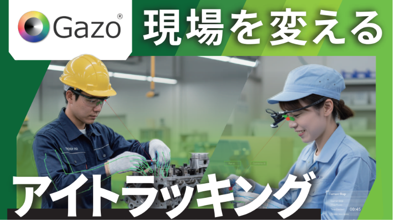
アイトラッキング(視線解析システム)
Eye Tracking (Gaze Analysis System)
「アイトラッキング」は、作業者の“視線”を可視化し、どこを見て、どのように判断しているかを解析できる視線解析システムです。
建設・土木・製造などの現場において、熟練者の判断や確認動作を見える化し、技能伝承や教育品質向上を支援します。
従来、ベテラン作業者がどこを確認し、何を基準に判断しているかは、言葉だけでは伝えにくい部分が多くありました。
アイトラッキングでは、視線の動きや注視ポイントを映像として記録・解析できるため、経験や勘に頼っていた暗黙知を可視化できます。
点検作業や安全確認、重機操作、施工確認などでは、熟練者と若手作業者の視線の違いを比較することで、確認漏れや判断ミスの分析にも活用できます。
また、教育・OJTでは、熟練者の視線映像を教材として活用することで、実践的かつ再現性の高い教育を実現します。
さらに、リモサポやギノサポらくらくマニュアルと組み合わせることで、一人称視点映像と視線情報を活用した、より分かりやすい動画マニュアル制作や技能分析が可能です。
アイトラッキングは、技能の可視化と標準化を支援し、教育負担軽減、品質向上、人材育成、現場DX推進に貢献します。
“Eye Tracking” is a gaze analysis system that visualizes where workers are looking and how they make decisions. In construction, civil engineering, manufacturing, and other field operations, it helps visualize the judgment and confirmation processes of skilled workers, supporting skill transfer and improved training quality.
Traditionally, it has been difficult to explain exactly what experienced workers focus on and how they make decisions using words alone. Eye Tracking records and analyzes gaze movement and fixation points as video data, making tacit knowledge based on experience and intuition visible and easier to understand.
For inspection work, safety checks, heavy equipment operation, and construction verification, differences in gaze patterns between experienced and less experienced workers can be compared to identify overlooked points and improve operational accuracy. In training and OJT, gaze-recorded video from skilled workers can also be used as practical educational content.
In addition, by combining Eye Tracking with “Remosapo” and “Ginosapo Easy Manual,” it becomes possible to create more effective training videos and perform advanced skill analysis using first-person video and gaze information together.
Eye Tracking supports the visualization and standardization of skills, contributing to reduced training burdens, improved quality, workforce development, and digital transformation in field operations.
共同出展社:キタック
共同出展社:KITAC
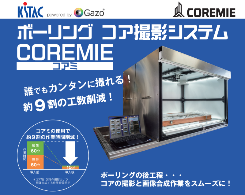
ボーリング コア撮影システム「COREMIE」
Boring Core Imaging System “COREMIE”
ボーリング コア撮影システム「COREMIE」は、地質調査や建設現場における土質判定作業の効率化と品質安定化を目的に開発されたシステムです。
地質調査会社、建設コンサルタント、土木・建設会社など、幅広い分野での活用を想定しています。
「COREMIE」は、ボーリングコアの撮影・画像処理・色判定を行う「COREMIEフォトキット」と、撮影済み画像をAI解析し土質判定を支援する「COREMIE AI Pro」で構成されています。
従来は手作業中心だった撮影・画像整理・判定業務を効率化し、判定精度向上と作業時間短縮を実現します。
「COREMIEフォトキット」では、ボーリングコアの撮影から画像補正・合成までを簡単かつ高速に行うことが可能です。
撮影後は画像が自動で補正・合成されるため、手作業に比べ短時間で画像データを準備できます。
従来工程と比較して、撮影から画像合成までの工数を約9割削減できます。
また、撮影ブースはキャスター付き専用架台を採用しており、現場や出先への持ち運びにも対応しています。 大型商用バンへの積載も可能で、柔軟な運用を実現します。
さらに、難しいカメラ設定が不要なため、誰が撮影しても安定した品質で撮影可能です。
LED照明を搭載しているため、天候や時間帯に左右されず撮影できます。
撮影した画像は「COREMIE AI Pro」が解析し、土質区分基準に準拠した判定結果を生成します。
これにより、経験やスキルによる判断のばらつきを抑え、安定した品質管理を支援します。
また、人的作業や確認時間の削減、再撮影の減少により、調査業務全体の効率化とコスト削減にも貢献します。
The Boring Core Imaging System “COREMIE” was developed to improve efficiency and stabilize quality in soil classification work for geological surveys and construction projects.
It is designed for use across a wide range of fields, including geological survey companies, construction consultants, and civil engineering and construction companies.
“COREMIE” consists of two components: the “COREMIE Photo Kit,” which performs boring core photography, image processing, and color analysis, and “COREMIE AI Pro,” which uses AI to analyze captured images and support soil classification.
The system streamlines traditionally manual workflows for photography, image organization, and classification, improving accuracy while reducing processing time.
The “COREMIE Photo Kit” enables fast and easy photography, image correction, and image composition of boring cores.
Captured images are automatically corrected and combined immediately after shooting, allowing image data to be prepared much faster than with conventional manual methods.
Compared with traditional workflows, the labor required from photography to image composition can be reduced by approximately 90%.
The photography booth is mounted on a dedicated stand with casters, making it easy to transport and suitable for use both on-site and in remote locations.
It can also be loaded into a commercial van for flexible operation.
In addition, no complex camera settings are required, allowing stable image quality regardless of the operator.
LED lighting is built into the booth, enabling consistent photography regardless of weather or time of day.
Captured images are analyzed by “COREMIE AI Pro” to generate classification results based on soil classification standards.
This helps reduce variations caused by differences in experience and skill level, enabling more stable quality control.
In addition, reduced manual work, shorter confirmation time, and fewer retakes contribute to improved operational efficiency and lower overall survey costs.
土質判定支援システム「COREMIE AI Pro」
Soil Classification Support System “COREMIE AI Pro”
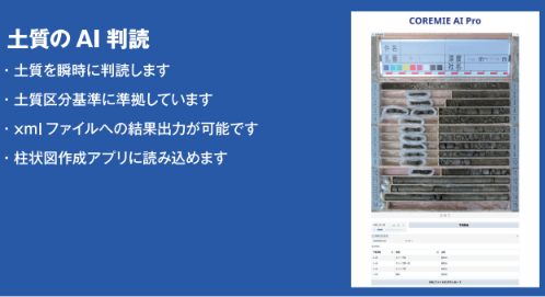
「COREMIE AI Pro」は、ボーリングコア画像をAIで解析し、土質判定を支援するシステムです。
地質調査や建設・土木分野における土質判定業務の効率化と品質安定化を目的として開発されました。
効率良く働ける職場づくりを支援し、土質判定から書類作成までの半自動化を実現します。
「COREMIEフォトキット」で撮影・合成した画像をAIが瞬時に解析し、土質区分基準に準拠した判定結果を生成します。
従来は技術者の経験や目視確認に依存していた判定業務をAIで支援することで、判定のばらつきを抑え、安定した品質管理を実現します。
また、AIによる解析結果を活用することで、判定作業や確認作業の時間短縮にも貢献します。
若手技術者でも一定水準の判定を行いやすくなり、ベテラン技術者への負担軽減や技能継承支援にもつながります。
解析結果はXMLファイルとして出力可能で、柱状図作成アプリへの読込にも対応しています。
これにより、判定結果をそのまま書類作成へ活用でき、報告書作成や社内共有の効率化を支援します。
撮影から判定、書類作成までを一連の流れで効率化することで、調査業務全体の生産性向上とコスト削減に貢献します。
「COREMIE AI Pro」は、経験や感覚に頼りやすかった土質判定業務を、AIと画像解析技術によって標準化し、地質調査・建設分野における現場DXを推進します。
“COREMIE AI Pro” is a system that uses AI to analyze boring core images and support soil classification. It was developed to improve efficiency and stabilize quality in soil classification work for geological surveys and civil engineering and construction projects. The system supports more efficient workflows by enabling automatic soil classification and semi-automation of documentation tasks.
AI instantly analyzes images captured and combined using the “COREMIE Photo Kit” and generates classification results based on soil classification standards. By supporting tasks that traditionally relied on engineer experience and visual inspection, the system reduces variations in judgment and enables more stable quality control.
AI-based analysis also contributes to shorter processing and confirmation times. Even less experienced engineers can perform classification more consistently, helping reduce the workload on skilled specialists while supporting workforce training and skill transfer.
Analysis results can be exported as XML files and imported into columnar diagram creation applications. This allows classification data to be directly utilized for documentation, improving report preparation and internal information sharing. By streamlining workflows from image capture and classification to document creation, the system improves overall productivity and reduces operational costs.
“COREMIE AI Pro” standardizes soil classification work that has traditionally depended on experience and intuition through AI and image analysis technologies, promoting digital transformation in geological surveys and construction fields.