基本情報
出展製品・サービス
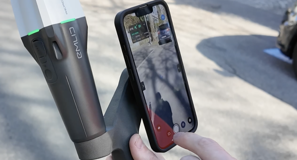
スマートフォン計測ソリューション「PIX4Dcatch RTK」
Mobile 3D measurement technology ”PIX4Dcatch RTK”
PIX4Dcatch RTK は、写真測量技術とRTK測位を組み合わせた、 スマートフォン対応の高精度3D測量ソリューション です。また、写真に加えてiPhone Proの LiDAR技術を活用するため、PIX4DcloudまたはPIX4Dmatic(Standard, Pro)を用いることにより高密度な点群の生成が可能です。
本製品を使用することで、 写真とLiDARを組み合わせた3D点群データやメッシュモデルの生成 が可能となり、同様に高解像度のオルソモザイクやDSM などの2D成果物も作成できます。
GNSSローバーを使用した際のRTK測位の位置精度は 相対誤差1cm、絶対誤差5cm以内 という高精度を誇り、測量・建設・インフラ管理・開発案件における境界確定・不動産開発など、幅広い分野で活用できます。
スマートフォンを活用した手軽さとGNSS補正による高精度測位を兼ね備えたPIX4Dcatch RTK。
次世代の測量技術 を、ぜひ展示会でご体感ください。
PIX4Dcatch RTK is a high-precision Mobile 3D measurement technology compatible with smartphones, combining photogrammetry technology with RTK positioning. Furthermore, by utilizing the iPhone Pro’s LiDAR technology in addition to photographs, it enables the generation of high-density point clouds using PIX4Dcloud or PIX4Dmatic (Standard, Pro).
Using our product, it is possible to generate 3D point cloud data and mesh models combining photographs and LiDAR, and similarly, create high-resolution 2D deliverables such as orthomosaics and DSMs.
With GNSS rover use, the RTK positioning accuracy boasts high precision with a relative error of 1 cm and an absolute error of within 5 cm, making it applicable to a wide range of fields including surveying, construction, infrastructure management, boundary demarcation in development projects, and real estate development.
PIX4Dcatch RTK combines the ease of use of smartphones with high-precision positioning through GNSS correction.
Please try this new generation of 3D measurement technology at our booth.
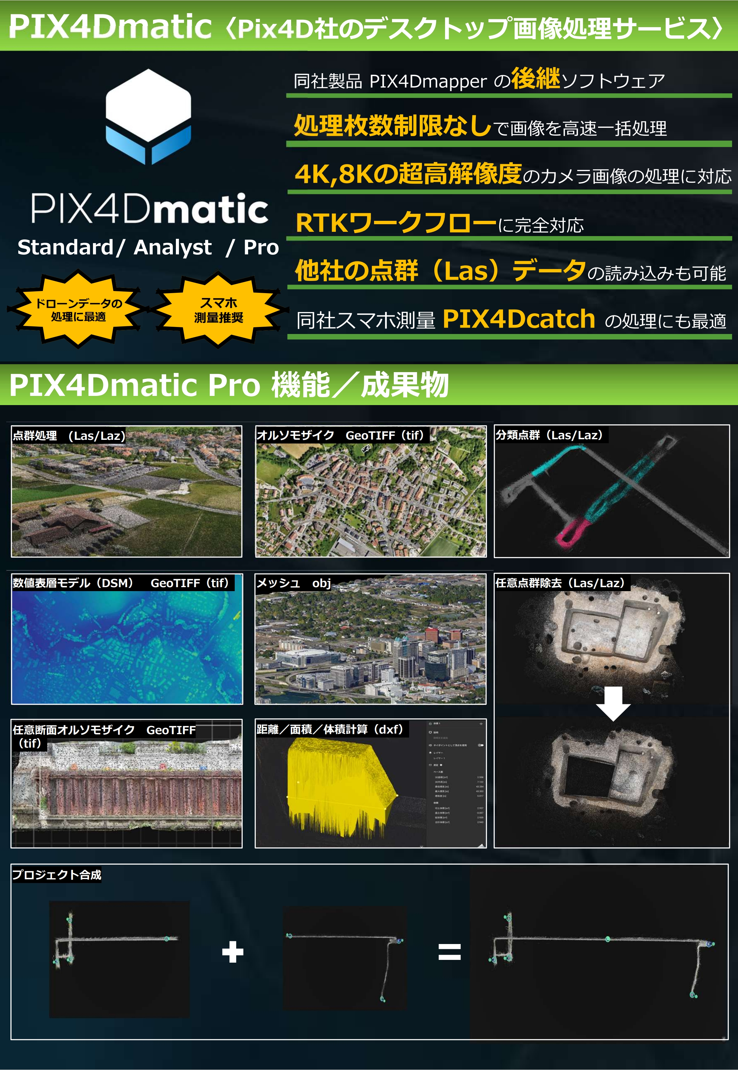
新世代フォトグラメトリソフトウェア「PIX4Dmatic」
Next-generation photogrammetry software "PIX4Dmatic"
PIX4Dmaticは、次世代の写真測量ワークフローを実現するため、Pix4D社(本社:スイス)が開発したフォトグラメトリソフトウェアで、写真データとLiDARデータの両方を統合処理できる高度な技術を搭載し、RTK(リアルタイムキネマティック)ワークフローにも完全対応。RTKドローンやPIX4Dcatch RTKで取得した高精度データを高速に処理し、測量・マッピングの業務をより効率化します。
また、超高解像度のカメラ画像処理や、10,000枚を超える画像を一括処理など、大規模なプロジェクトにも対応できる高性能な画像処理エンジンを備えています。
本ソフトウェアを活用することで、以下のような高精度な成果物を作成できます:
(1)3次元モデル:高密度点群(写真由来)、深度点群(LiDAR由来)、合成点群(写真+LiDAR)、3Dメッシュモデル
(2)2次元モデル:高解像度オルソモザイク、数値表層モデル
(3)品質レポート
PIX4Dmaticは、建設、測量、インフラ管理、災害対策、文化財調査、環境調査など、幅広い分野での活用が可能です。
PIX4Dmatic is photogrammetry software developed by Pix4D (headquartered in Switzerland) to realize next-generation photogrammetry workflows. It features advanced technology that integrates and processes both photographic and LiDAR data, and is fully compatible with RTK (Real-Time Kinematic) workflows. It processes high-precision data acquired by RTK drones and PIX4Dcatch RTK at high speed, making surveying and mapping operations more efficient.
Furthermore, it boasts a high-performance image processing engine capable of handling large-scale projects, including ultra-high-resolution camera image processing and batch processing of over 10,000 images.
This software allows you to create highly accurate deliverables such as:
(1) 3D models: High-density point clouds (photograph-derived), depth point clouds (LiDAR-derived), composite point clouds (photographs + LiDAR), 3D mesh models
(2) 2D models: High-resolution orthomosaics, digital surface models
(3) Quality reports
PIX4Dmatic can be used in a wide range of fields, including construction, surveying, infrastructure management, disaster prevention, cultural property surveys, and environmental surveys.
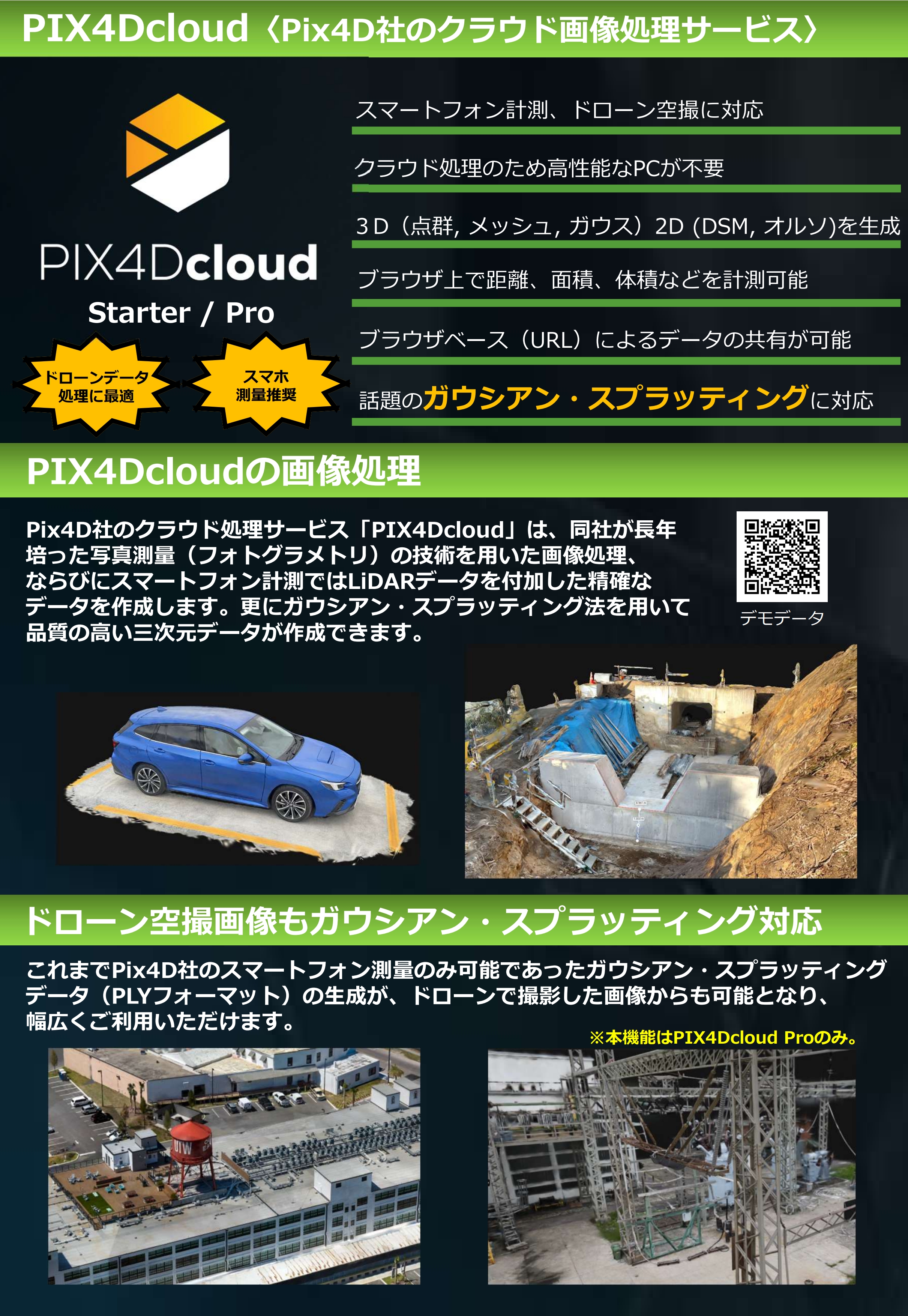
現場DX最適化クラウドサービス「PIX4Dcloud」
Digital Transformation Cloud Platform “PIX4Dcloud”
PIX4Dcloudは、現場で取得したデータをクラウド上で処理・共有できる、クラウド型のマッピング・解析プラットフォームです。
ドローンやスマートフォンで取得した画像データをアップロードするだけで、高精度なオルソモザイクや3Dモデルを自動生成。専用の高性能PCを必要とせず、インターネット環境があれば、いつでもどこでもプロジェクトの確認・共有が可能です。
また、Webブラウザ上での計測、注釈追加、土量計算、時系列比較などの機能を備えており、施工進捗の確認や出来形管理、現場状況の可視化を効率的に行えます。現場担当者・施工管理者・発注者など、関係者間でのスムーズな情報共有を実現し、迅速な意思決定を支援します。
本ソフトウェアを活用することで、以下のような成果物・業務支援が可能です:
(1) 2次元成果物:高解像度オルソモザイク、注釈付きマップ、距離・面積計測
(2) 3次元成果物:3D点群、3Dビュー、現場の立体可視化
(3) 解析機能:土量計算、標高差確認、進捗比較、変化検出
(4) 共有機能:ブラウザ閲覧、URL共有、遠隔確認、関係者との共同活用
PIX4Dcloudは、建設、土木、測量、インフラ管理、災害対応、環境調査など、幅広い現場業務のDXを推進するクラウドソリューションです。
PIX4Dcloud is a cloud-based mapping and analysis platform that allows you to process and share data acquired on-site in the cloud.
Simply upload image data acquired from drones or smartphones, and it automatically generates high-precision orthomosaics and 3D models. It doesn’t require a dedicated high-performance PC; with an internet connection, you can check and share projects anytime, anywhere.
Furthermore, it features functions such as measurement, annotation, earthwork volume calculation, and time-series comparison via a web browser, enabling efficient monitoring of construction progress, completion management, and visualization of site conditions. It facilitates smooth information sharing among stakeholders, including site managers, construction supervisors, and clients, supporting rapid decision-making.
This software enables the creation of the following deliverables and operational support:
(1) 2D deliverables: High-resolution orthomosaic, annotated maps, distance and area measurements
(2) 3D deliverables: 3D point clouds, 3D views, 3D visualization of the site
(3) Analysis functions: Earthwork volume calculation, elevation difference confirmation, progress comparison, change detection
(4) Sharing functions: Browser viewing, URL sharing, remote verification, collaborative use with stakeholders
PIX4Dcloud is a cloud solution that promotes Digital Transformation in a wide range of field operations, including construction, civil engineering, surveying, infrastructure management, disaster response, and environmental surveys.